
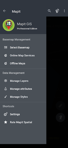
Features Mapit GIS Professional
Mapit GIS Professional: Elevating Your Mapit GIS Experience for Android 11+Welcome to Mapit GIS Professional, your comprehensive GIS mapping companion.
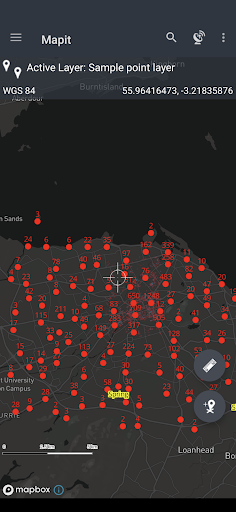
Embrace a new era of spatial data management with cutting-edge features tailored to meet the demands of various applications involving spatial data collection on mobile devices.Key Features:Mapbox SDK Integration:Navigate through spatial data with precision using the Mapbox SDK, providing a visually stunning and powerful mapping experience.
Access detailed maps for an accurate representation of your surveyed areas.Geopackage Project Efficiency:Manage your data effectively through geopackage projects, streamlining survey design and data sharing across different applications.
The apps lightweight design ensures optimal performance.Field Linkage for Enhanced Data Collection:Geopackage feature layers can link fields with attribute set fields, facilitating data collection through forms with drop-down lists, multi-select lists, and barcode scanners.
Customize your data collection process according to the unique needs of each application.Coordinate Precision:Support for multiple coordinate projections ensures accuracy in diverse environments.
Specify your default coordinate system with the EPSG code, leveraging the PRJ4 library for precise coordinate conversion.High-Precision GNSS Integration:Link with high-precision GNSS systems to achieve centimetre-level accuracy.
Take advantage of RTK solutions provided by leading GNSS manufacturers for enhanced surveying capabilities.Export and Import Flexibility:Seamlessly export and import data in GeoJSON, KML, and CSV formats, facilitating compatibility with other GIS tools and ensuring smooth collaboration.Customization Options:Tailor Mapit GIS Professional to your unique needs by adding custom WMS and WFS services as overlays.
Choose from three measurement methods for accurate data capture.Revolutionized Data Management:Experience a seamless data management workflow, allowing you to capture, manage, and analyze spatial data effortlessly.
The apps redesigned approach ensures efficiency in various GIS applications.Future-Ready GIS Mapping:Mapit GIS Professional is committed to continuous improvement.
Please note that while the app is optimized for Android 11+, some features available in older apps may not be available yet.Stay tuned for our detailed development roadmap on our website, scheduled for release in Q1 2024.Mapit GIS Professional excels across a spectrum of applications, offering robust solutions for:Environmental SurveysWoodland SurveysForestry Planning and Woodland Management SurveysAgriculture and Soil Types SurveysRoad ConstructionLand SurveyingSolar Panel ApplicationsRoofing and FencingTree SurveysGPS and GNSS SurveyingSite Surveying and Soil Sample GatheringSnow RemovalEmpower your GIS workflows across various sectors and make Mapit GIS Professional your go-to tool for precise spatial data management.
Explore the vast potential of GIS mapping across environmental surveys, forestry planning, agriculture, and beyond.
Elevate your GIS experience with Mapit GIS Professional today!
Secure & Private
Your data is protected with industry-leading security protocols.
24/7 Support
Our dedicated support team is always ready to help you.
Personalization
Customize the app to match your preferences and workflow.
See the Mapit GIS Professional in Action


Get the App Today
Available for Android 8.0 and above